
HikeGPS is designed for trails where cellular coverage may disappear. It stores maps on the device, distinguishes paths and trail types, and can record a hike with distance, pace, ascent, waypoints, and an elevation profile. Hikers can sketch routes, import or export GPX tracks, reverse a recorded route to backtrack, and view activity information on Apple Watch. An on-device model can suggest the identity of plants, birds, insects, or fungi from a photo without uploading it. The app is free, requires no account, and has no subscription listed. Its developer warns that GPS and elevation can be wrong, the app can use significant battery, and species matches are guesses—not a safety check. HikeGPS is a navigation aid, not a replacement for a map, compass, or training.

HikeGPS: Offline Trail Maps
An offline hiking map and GPS recorder with trail routing, GPX support, on-device species suggestions, and Apple Watch tracking.
Overview
A closer look at HikeGPS: Offline Trail Maps.
A closer look
App screenshots
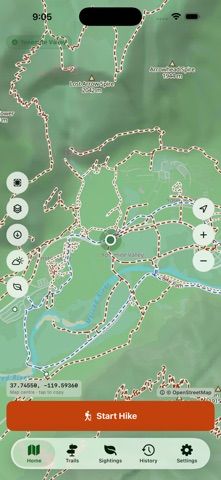
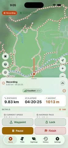
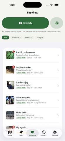

Choose with confidence
The useful details.
What it does
- Download offline trail maps and record hikes without a signal.
- Plan routes and import or export GPX tracks.
- Review distance, pace, ascent, waypoints, and elevation profiles.
- Use Apple Watch tracking and optional on-device species suggestions.
A good fit for
- Hikers who want offline trail maps, GPS recording, and GPX route handling on Apple devices.
Worth knowing
- GPS and elevation can be inaccurate and continuous recording uses battery; species identification is only a suggestion. The developer says the app does not replace navigation training, map and compass, or emergency equipment.
Frequently asked questions
Answers based on the app’s official listing and reviewed information.
What is HikeGPS: Offline Trail Maps used for?
An offline hiking map and GPS recorder with trail routing, GPX support, on-device species suggestions, and Apple Watch tracking.
What can you do with HikeGPS: Offline Trail Maps?
Download offline trail maps and record hikes without a signal. Plan routes and import or export GPX tracks. Review distance, pace, ascent, waypoints, and elevation profiles. Use Apple Watch tracking and optional on-device species suggestions.
Who is HikeGPS: Offline Trail Maps designed for?
Hikers who want offline trail maps, GPS recording, and GPX route handling on Apple devices.
What should you know before downloading HikeGPS: Offline Trail Maps?
GPS and elevation can be inaccurate and continuous recording uses battery; species identification is only a suggestion. The developer says the app does not replace navigation training, map and compass, or emergency equipment.
Does HikeGPS: Offline Trail Maps include paid features?
The reviewed listing reports no in-app purchases.
Which platforms support HikeGPS: Offline Trail Maps?
Greatooly's reviewed app information lists iOS.
Researched from official sources; this is not a hands-on review. Last checked 2026-11-04.
Keep exploring
More apps that might be a good fit.

Tripdrobe: Outfit Packing List
Plan outfits and packing lists by trip date, with premium weather, baggage, wardrobe, and group tools.

SkyFlight Tracker
A flight companion with live status, gate countdowns, route maps, layover risk alerts, airport weather, and travel statistics.

FLITx・Live Flight Tracker Map
A live flight map for searching aircraft and routes, checking flight status, and viewing nearby airport activity.