
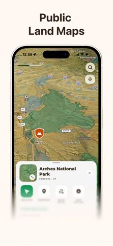
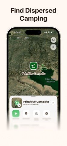
OffroadPal is an outdoor navigation app for overland riders and people exploring trails. Its map combines trail details such as difficulty, distance, elevation, access, and current conditions with satellite imagery, land boundaries, weather, wildfire information, and points of interest. Users can build routes, record rides, and download maps for areas with limited service. The app also shows dispersed-camping information along forest and BLM roads, including nearby facilities and possible fees. OffroadPal Pro unlocks offline maps, custom routes, advanced layers, and other ride tools, with availability varying by location. The listing cautions that land and access details can change; users should verify local rules and follow posted signs and land-manager guidance.

OffroadPal: GPS & Trail Maps
An off-road GPS and trail map app for discovering routes, viewing terrain and land information, and recording rides.
Overview
A closer look at OffroadPal: GPS & Trail Maps.
A closer look
App screenshots


Choose with confidence
The useful details.
What it does
- Find trails and riding areas with difficulty, distance, elevation, and access details.
- View satellite imagery, land boundaries, weather, wildfire information, and points of interest.
- Plan routes, record rides, and review route statistics.
- Download offline maps and access advanced tools with OffroadPal Pro.
A good fit for
- Off-road drivers and overland travelers who want trail information and navigation tools in one map.
Worth knowing
- Offline maps, custom routes, advanced map layers, and additional ride features require Pro; feature availability varies by location.
- Trail access and land information can change; verify local rules and posted guidance before a trip.
Frequently asked questions
Answers based on the app’s official listing and reviewed information.
What is OffroadPal: GPS & Trail Maps used for?
An off-road GPS and trail map app for discovering routes, viewing terrain and land information, and recording rides.
What can you do with OffroadPal: GPS & Trail Maps?
Find trails and riding areas with difficulty, distance, elevation, and access details. View satellite imagery, land boundaries, weather, wildfire information, and points of interest. Plan routes, record rides, and review route statistics. Download offline maps and access advanced tools with OffroadPal Pro.
Who is OffroadPal: GPS & Trail Maps designed for?
Off-road drivers and overland travelers who want trail information and navigation tools in one map.
What should you know before downloading OffroadPal: GPS & Trail Maps?
Offline maps, custom routes, advanced map layers, and additional ride features require Pro; feature availability varies by location. Trail access and land information can change; verify local rules and posted guidance before a trip.
Does OffroadPal: GPS & Trail Maps include paid features?
The reviewed listing does not confirm current in-app purchase options.
Which platforms support OffroadPal: GPS & Trail Maps?
Greatooly's reviewed app information lists iOS.
Researched from official sources; this is not a hands-on review. Last checked 2026-11-04.
Keep exploring
More apps that might be a good fit.

Tripdrobe: Outfit Packing List
Plan outfits and packing lists by trip date, with premium weather, baggage, wardrobe, and group tools.

SkyFlight Tracker
A flight companion with live status, gate countdowns, route maps, layover risk alerts, airport weather, and travel statistics.

FLITx・Live Flight Tracker Map
A live flight map for searching aircraft and routes, checking flight status, and viewing nearby airport activity.